


Le nez de Jobourg

PhilippeC54
User
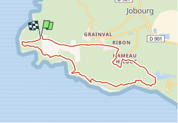

Length
9.3 km

Max alt
138 m

Uphill gradient
268 m
Km-Effort
12.9 km

Min alt
18 m

Downhill gradient
268 m
Boucle
Yes
Creation date :
2021-08-02 07:02:38.565
Updated on :
2021-08-02 10:08:33.078
2h31
Difficulty : Easy

FREE GPS app for hiking
 SityTrail
IGN / Geographical institutes
SityTrail Plus
The world is yours!
About
Trail Walking of 9.3 km to be discovered at Normandy, Manche, La Hague. This trail is proposed by PhilippeC54.
Positioning
Country:
France
Region :
Normandy
Department/Province :
Manche
Municipality :
La Hague
Location:
Jobourg
Start:(Dec)
Start:(UTM)
576564 ; 5503372 (30U) N.
Comments